
ISS Live Map: How to Read It and Keep It On Screen
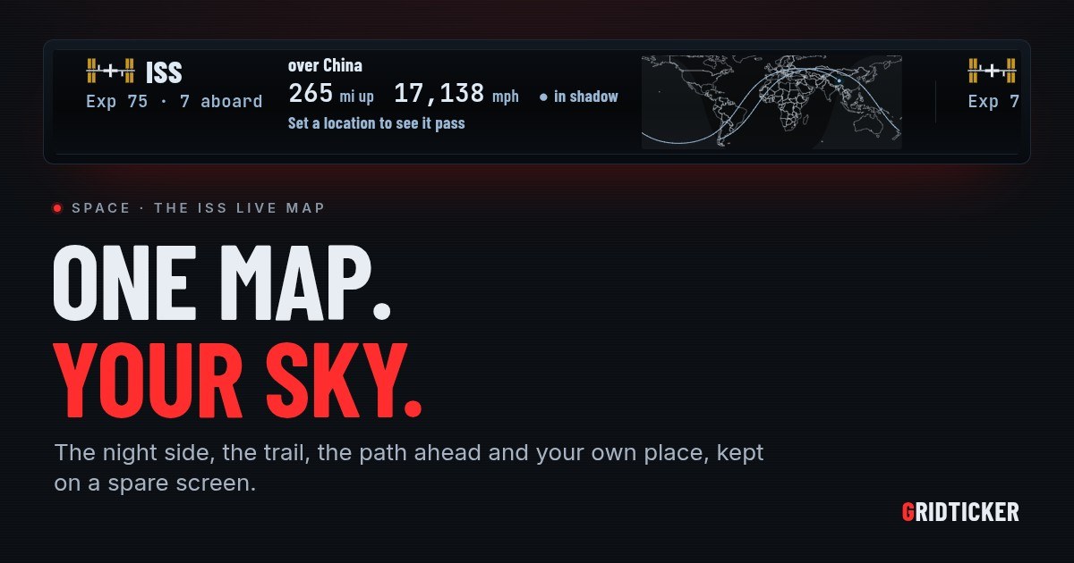
An ISS live map shows where the International Space Station is right now, drawn on a map of the whole world. A good one shows more than a dot. It shows the part of the planet in darkness, where the station has just been, where it is going next, and where you are. If you read those four things together, the map tells you whether the station is anywhere near you and whether you have a chance of seeing it. This article covers how to read each part of the map, and then how to leave one running on a spare monitor or a TV so it is there when you look up.
What an ISS live map shows
The station is always moving, so a live map is really a set of clues drawn over the same picture. Here are the parts and what each one tells you.
The station itself
The dot or icon is the station's position at this moment, over the ground directly below it. On a map that updates continuously, it creeps along by itself. On a map that refreshes now and then, it jumps.
The trail behind it
A line behind the station shows where it has just been. It is useful because the station's path across a flat map curves. A short stretch of that curve shows which way it is heading better than a single dot can.
The path ahead
A line in front of the station, often dashed, is where it is going next. This is the line to check against your own location. If it passes near you, the station will be overhead. If it passes far away, it won't be this time around.
The night side
Many maps shade the half of the world that is in darkness. This is the part most people skip, and it matters most for seeing the station. The station shines by reflecting sunlight, so you can only see it when two things are true at once: the station is in sunlight and your sky is dark.
Your place
A marker for where you are turns a world map into a map about you. Without it, you have to work out the distance between the station's path and your town yourself.
How to read the map for a sighting
Put the parts together and you get a quick test:
- Find your marker. Is it on the shaded night side? If you are in full daylight, you won't see the station, however close it passes.
- Follow the path ahead. Does the dashed line come near your marker? A path that crosses the far side of the ocean won't give you anything.
- Check the station's light. If your sky is dark and the station passes nearby while it is still in sunlight, it can show up as a bright, steady point moving across the sky.
This is why sightings cluster around dusk and dawn. For an hour or two after sunset, or before sunrise, the ground is dark but the station, high above, is still in sunlight. Deep in the night, the station is usually in Earth's shadow too.
Why a map you have to open falls short
Most people pull up an ISS live map in a browser tab, look once, and close it. The station will probably be over an ocean, because most of the planet is ocean. The good moments, a pass over your own sky at dusk, come in runs and are easy to miss when you have to remember to check.
A map that stays up on a screen you already glance at fixes that. You watch the station's path drift from one orbit to the next, you notice when the dashed line starts crossing near your marker, and you get a warning when a pass is coming.
How GridTicker helps with an ISS live map
GridTicker is a live ticker that runs in a browser on a spare screen, a second monitor or a TV, and the space station is one of the things it can show. There is nothing to install: it runs in any modern browser, on Windows, macOS, Linux or a Raspberry Pi, full screen or in a window.
The ISS card
The ISS card has the map described above. It shows the whole world with the night side shaded, where the station has been in the last 45 minutes, and a dashed line for where it is going next. The station moves along it second by second, and your place is the ringed dot. The card also says what the station is over right now, how high and how fast it is going, whether it is in sunlight, and who is aboard. The bottom line gives the next time it can be seen from your place.
Your place on the map
You set your place on the Space page by typing an airport code or using your browser's location (Where you watch the sky from). If you leave it blank, GridTicker uses your Flights location, and if that is empty too, your first weather place.
Which passes count
The ISS and China's Tiangong can each be seen when the station is in sunlight and your sky is dark. That usually means an hour or two after sunset or before sunrise, in runs a week or two apart. A setting under The space stations decides which passes count, for the card and for the alert. You can count every pass above 10 degrees, or only passes that clear the trees (20), passes a third of the way up (30), or high passes only (40). Each station is its own feed, switched on for the screens you choose, so you can follow the ISS, Tiangong or both.
When a pass is coming
Alerts take over the screen from five minutes before the station comes into view, with a countdown and which way to face. While it is up, the screen shows a sky: the horizon as a circle, with straight up at its center. The station is drawn where it is at that moment, and the screen says how high to look, in degrees and in fists held at arm's length. Each alert can be switched off on its own. An alert shows only on screens where its card is switched on, and never on a screen a schedule has turned off.
Keeping it to the hours you want
Schedules set the hours each ticker shows on each screen. That way you can keep space on through the evening and turn it off at bedtime.
For more on the curve the station traces across the map, see How to Read Its Ground Track. To set up a strip with the space station on it, start at https://app.gridticker.com/signup.